Last week, late local time on a Wednesday night, I was excitedly listening and watching presentations, writing notes and tweeting as a result of the the Digital Preservation Coalition’s (DPC) online seminar “Where are we now? Mapping progress with geospatial data preservation”.
When we saw that the DPC were putting on an event that included both archives and spatial data, I was super keen to be involved. My first degree in Geography was all about spatial data – the love of which persisted through my ecology and environmental stage of my career to see the creation of Gaia Resources. Along the Gaia Resources journey, as I talked about briefly at the recent Archival Society of Australia WA branch meeting, we have ended up working with Archives all around Australia… and then suddenly there was the DPC event, combining those two topics and giving me an excuse to stay up late and enjoy myself.
The event itself was run online, and included a series of talks followed by a short question and answer piece at the end, with some good breaks in between to present attendees from going mad looking at a screen for four straight hours. The event itself was expertly facilitated and run by the DPC staff, which is still no mean feat these days.
The talks were varied, and included groups from a variety of organisations and industries, including:
- Organisations that were decommissioning first generation nuclear power plants in the UK, and trying to deal with the challenges of legacy spatial data,
- The British Geological Survey, who provided an overview of how they’re going to deliver their spatial data into the future (more on that later)
- Data standards bodies like Geonovum in the Netherlands, who pointed out how the W3C and OGC standards have been separated for way too long, but have been brought together with their joint working groups,
- The UK Geospatial Commission, who were discussing how to provide data of high quality, that was also Findable, Accessible, Interoperable and Readable (FAIR),
- The US Library of Congress, talking about what sorts of formats they accept into their archive through their Recommended Format Statement,
- A case study in the archaeology profession in the UK (and the lingering love of the shapefile), and
- A final case study on the National Library of Scotland, and how they are preserving historical maps and making those available (and I then spent ages browsing their website – linked below).
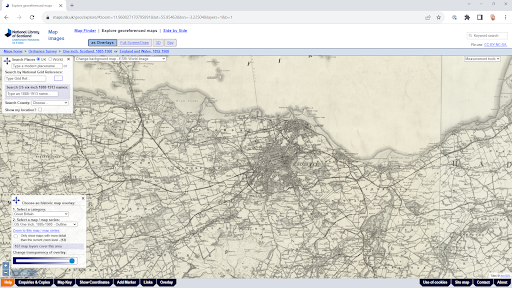
The National Library of Scotland “Map Images” website – find it at https://maps.nls.uk/geo/explore/
There was a lot of content in here to digest, and I pulled out a few points that I’ll summarise as the highlights for me, which were:
- The rise of the Geopackage – as highlighted early in the British Geological Survey talk, they are moving towards delivering data in API style feeds (using the OGCAPI feeds) and delivering files in GeoTIFF, GeoJSON and Geopackage only. This was echoed in the Library of Congress preferring the GeoPackage format as well – and for many good reasons. If you’re working with digital spatial data, then you need to start investigating Geopackages and how they’re emerging as a great open standard,
- International differences – listening to talks from the nuclear decommissioning crews and the archaeologists reminded me of how spatial data in the mining industry was at way back in the early days of Gaia Resources when we were working with Western Australian mining companies to digitise all their legacy spatial data, and how far we’ve come since then – which will be the subject of a future blog from me as well,
- Active community – there are a whole raft of people out there in the world who are looking at the same challenges we are in terms of digital preservation of spatial data, and the DPC seems to be a great place to connect to them – which we’ll be doing, and we’ve reached out to the DPC to see how we can help and be involved, and
- Practical, pragmatic implementation – while I love detailed standards like any other spatial/archiving nerdy type, the practical applications of these were what really stood out in the talks. Standards can often be developed in ivory towers, away from the practical implementation of them, but I saw some very close touchpoints here across the talks and as a result, there is plenty of good guidance for operators to follow.
I was also pleased – and somewhat relieved – to see a whole bunch of things in the talks that reminded me of work that we’ve done. Apart from the example of our digitisation work in the mining sector here in Western Australia, the National Library of Scotland “Map Images” site is our Retromaps project on steroids, and there was a fair bit of thought around the use of GeoPackages, which we’re building into several of our larger data collation and aggregation projects at the moment.
It’s definitely useful to see historical data, and making it available is a challenge. We had a go at @gaiaresources with the Retromaps project with @StateRecordsWA https://t.co/PmFxm92qPi #dpc_geo #archives #spatial
— Piers Higgs (@piers_higgs) March 30, 2022
This was my first introduction to the DPC – I’ve heard about them before, but never been actively able to participate in an event. It certainly was worth staying up late to get these different perspectives and how these different players deal with those challenges of archiving spatial data.
If you’d like to talk more about the event, or find out more about how we’re working on capturing, managing and archiving spatial data in a range of industries here at Gaia Resources, feel free to drop us an email or start a conversation on our social media platforms – Twitter, LinkedIn or Facebook.
I must also say thanks once again to the team behind DPC, and all of the speakers, for an interesting Wednesday night!
Piers
Comments are closed.