Overview
In early 2021, the Forest Fire Management group at the Department of Environment, Land, Water and Planning (DELWP) engaged Gaia Resources to undertake a technical investigation of spatial tools that could help in bushfire risk management in the Hume region of Victoria, Australia. Monitoring forest canopy change through remote sensing was seen as an emerging operational capability that could provide important information and trends to inform the agency about increased risks of catastrophic burns in a changing climate.
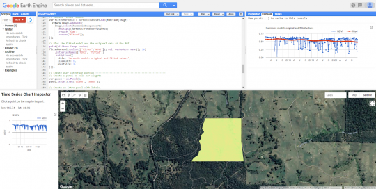
Our Data Science team undertook a literature review focused on Sentinel-1, Sentinel-2 and Landsat based applications, along with a review of current field practices. The investigation then worked out two step-by-step processes leveraging a 3 year rolling baseline of satellite imagery processed with Jupyter Notebooks and Google Earth Engine. A final report details these elements and how DEWLP could implement an operational toolset to process new imagery and compare changes in NDVI (Normalised Difference Vegetation Index) above or below the baseline thresholds.
Considered by the client to be a ‘roaring’ success, the report has triggered productive conversations about a statewide monitoring approach, and our team is looking forward to a second stage of implementation work for the Department’s operational use.
Services
Data Science / Remote Sensing / Spatial