Overview
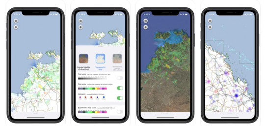
Gaia Resources worked closely with the Northern Australia and Rangelands Fire Information (NAFI) to design and build the app, which you can now download onto your device now from the Apple Store or Google Play Store.
The app reflects the powerful data products available from the NAFI website that are already used extensively across projects and programs in the north of Australia to monitor savanna burning programs and bushfires. Fire scars are displayed representing remotely sensed burnt areas coloured by the month of the fire, as are thermal hotspots detected from an array of satellites. These data layers are presented in an intuitive mapping interface with a small selection of base maps, location and compass direction functionality. Hundreds of thousands of hotspots are rendered seamlessly using a heatmap algorithm, and the app works both in real time and has offline capabilities, so that it can work even when you are out in the field.
This app brings the most used fire information resource for land managers in Australia to your phone, allowing you to keep a constant eye on bushfire threats. As a pastoralist, grazier, indigenous ranger, conservation scientist or member of the public, you can view maps of recent fire activity (hotspots) and burnt areas (fire scars) provided by the North Australia and Rangelands Fire Information (NAFI) service.
You can read more about the launch of the app in our blog here.
Services
Mobile / Software Engineering / Spatial