Overview
The Public Open Space (POS) Tool has been developed by Gaia Resources for the University of Western Australia’s Centre for the Built Environment and Health.
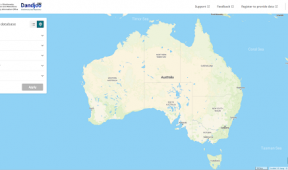
POS Tool provides information on the provision and location of public open space (POS) and the facilities and amenities provided within parks across Perth and Peel.
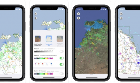
- For the general public – POS Tool offers a quick and simple way to find local parks in your local area and see what facilities are provided. You can find your closest park or locate a park with a certain facilities.
- For planners and developers – POS Tool can help you with your planning decisions. You can visualise and assess the spatial distribution of POS (including parks, nature and bushland) by suburb or local government authority across the Perth and Peel Metropolitan Region and analyse summary data on POS provision, park amenity, gaps in current provision and future needs.
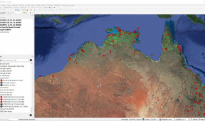
- For researchers – POS Tool provides an opportunity to assess and export POS-related information for use in research projects requiring data on POS (including parks, nature and bushland, school grounds, and residual areas). POS variables can be exported and used in combination with other datasets such as census or your own dataset.
Gaia Resources developed the POS Tool web site, including the mapping and other components that power this on-line system.
Update November 2013: As documented in our blog, the POS Tool won the “Best Planning Ideas – large Project Awards” at the 2013 Western Australian Awards for Planning Excellence.
Services
Software Engineering / Spatial