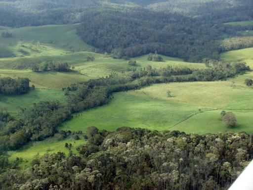
One of the side effects of urban and agricultural development is vegetation fragmentation, which affects biodiversity conservation and environmental quality. In order to restore and protect existing habitat, it is important to provide linkages between fragmented areas, which will encourage the movement of wildlife, preserving and improving biodiversity. According to the Department of Agriculture, Water and Environment, wildlife corridors are ‘connections across the landscape that link up areas of habitat. They support natural processes that occur in a healthy environment, including the movement of species to find resources, such as food and water’.
Last year we were contacted by the Shire of Mundaring to design wildlife corridors in their local government area. The purpose was to maintain a healthy landscape, restoring connectivity and promoting local biodiversity through the expansion of available habitats. As a solution, we conducted a spatial analysis using QGIS to derive the optimum paths to establish connectivity between vegetation patches, considering a few datasets of a sufficiently high level resolution.
It is interesting to see how there are many toolboxes developed to design wildlife corridors using licensed GIS software, but not many of them are available to add in open source software. There are a few models that can be downloaded as standalone software, which aim to find optimum restorations paths or connect reserves. The problem with these is that they can be out of date (you can encounter many bugs while trying to get your results) or the parameters you can control are very limited, so there is little room for tailoring the corridors to your preference.
Open-source software tools and plugins are often developed for a specific purpose and then put out to the public domain ‘as-is’ for others to adapt. For these niche applications, that might be as far as they get, and when you want to use them you are either limited to those application constraints or faced with a development cost to adjust the tool to your needs. There seems to be an opportunity here actually, to adapt open-source tools in QGIS and other software, and offer a solution that is tailored to defining wildlife corridor options. So I am looking into that as part of my professional development at Gaia Resources, and should have some news around this in the not-to-distant future!
The Least-Cost Path is one of the many plugins that can be added to QGIS. This kind of multi-criteria analysis is very popular for designing corridors for a range of applications like wildlife conservation and infrastructure planning.
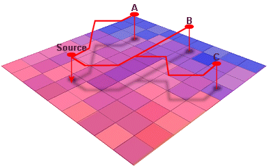
The concept behind performing a Least Cost Path analysis is the following: given an origin and a destination point, the algorithm will search in a cost raster for the cells with the minimum value and create a corridor between them.
If you are not familiar with GIS jargon, you might be wondering what a cost raster is. Long story short, the cost raster represents the potential resistance faced while transiting that path, and it combines a number of parameters that we’ll look into in a bit more detail below. Basically, each cell in your cost raster is the aggregation of scores that you apply to the input parameters.
Let’s think of all the parameters that need to be considered while designing corridors, with the idea that each of these can be sourced as data inputs into the cost raster. First and foremost: vegetation, an essential component that provides habitat and shelter for biodiversity. Next, we want to provide some source of water for the wildlife, so this element should also be included.
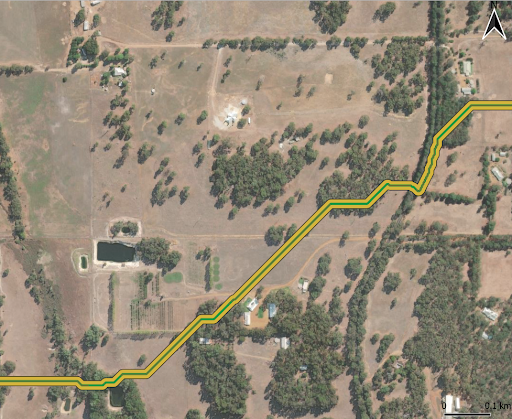
Knowing the land use types is also important while planning this kind of development, since some of them will be better to restore vegetation than others (I do not want to think of bandicoots establishing their home near a highway!). Talking about roads, that is another key dataset, since it would be ideal to avoid them (although crossing them is also possible, like in this example). Other datasets can be considered in this kind of study as well, it all depends on the requirements you want to cover with your corridors.
These parameters are given scores according to different criteria, considering how suitable they are for conservation purposes – and the scores are applied to the input datasets. For example, a criteria could be ‘main roads should be a severe impediment to wildlife corridor crossings, and wildlife corridors should not be present within 10m of a main road’. When the criteria are defined they will be assigned different scores according to a ranking, i.e. highways will have a higher cost than a minor road. Once the datasets are ready, they can be merged, and the scores will be added to each other; the final merged layer represents the cost raster that serves as input in the Least Cost Path plugin.
The model will create a corridor connecting one source point to a destination, or many corridors from a source to various points. A distinct advantage of using the Least Cost Path algorithm is that it is data-driven; it selects paths through analysis of inputs with defined rules that would otherwise be subjective and counter intuitive to choose while doing a visual analysis of the area. The idea is that the paths chosen by the tool will have a lower overall cost based on the data inputs.
Data-driven models will often lead to some unexpected results, and a review of the results can highlight additional perspectives, missed criteria, opportunities for improvement or data inputs that can be better handled. This makes wildlife corridor mapping an iterative process, but the model itself is robust and, once established, can be repeated with ease. For example, you can incorporate particular strategic planning areas not represented in the land use dataset you used in the last run of the model, or introduce firebreaks and ideal spots for wildlife cross-overs to overcome barriers on main roads.
The corridors obtained from the model can be given different priorities, as they will have an assigned cost as a result of crossing through different areas. Since the corridors have diverse lengths, a good practice is to obtain the cost/length ratio. This helps organisations to decide – alongside environmental and planning objectives – where the best value is for their revegetation and investment.
We can all help protect biodiversity by managing the environment in local areas. Organisations can use wildlife corridors to make meaningful engagement with landowners and feed into the planning process – giving everyone a chance to contribute to the local biodiversity in their area. If this project sounded interesting to you and would like to do something similar, reach out and start a conversation with us via email, or through our social media platforms – Twitter, LinkedIn or Facebook.
Rocio
Comments are closed.