Overview
In late 2017, Gaia Resources were approached by an environmental consultancy to investigate the use of free and open-source QGIS and Saga software for processing and analysing data captured by drones for environmental compliance monitoring in the mining industry.
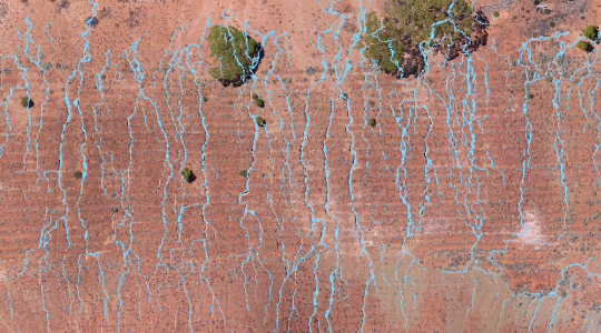
Over the following months, we assisted the client to develop a set of technical processes that could take elevation models derived from drones and assess slope, height, erosional features and other compliance conditions for mine site waste dumps, tailing structures and bunds. The technical processes involved step-by-step documentation to allow the consultancy to effectively create report map output and flag compliance issues. The project also involved a knowledge transfer to the client’s environmental scientists so they could understand how to repeat the process and build their internal capability.
Services
Business Analysis / Environmental compliance / Spatial / Training