Overview
In December 2017 the spatial team at Gaia Resources were engaged by Fisher Research to recommend and configure an off-the-shelf field data collection app for mapping and monitoring weeds within Trigg Bushland Reserve in the City of Stirling, Western Australia.
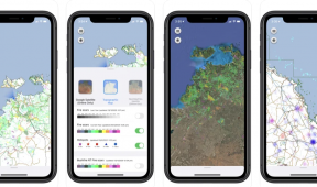
The team had previously reviewed over 45 mobile mapping apps in the market, and Mappt was selected for this project. A standardised form was configured to capture a number of attributes that would characterise a weed cover area, including weed community type, dominant species and stage (e.g. flowering, seeding). Other important layers like imagery and administrative layers were sourced from the City of Stirling and Landgate.
The person in the field is able to capture geo-tagged and time-stamped photographs along with the form information, and the collected data is then synchronised to a field laptop and used to feed into an annual weed management report for the local council to help them plan treatment activities and ongoing monitoring.