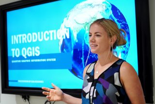
Gaia Resource’s Environmental QGIS Course for Beginners has been met with great enthusiasm by the many attendees in WA over the past few years – so much so that we decided to offer it to our friends up in the NT, on the back of the 2020 North Australia Savanna Fire Forum. This time around, Chris and I condensed the content into a somewhat intense one-day course, which really accentuated the need to focus on effective teaching rather than just delivering content.
Discussing the important matters of fire escapes and where to buy the best coffee.
When writing the course material, we ask ourselves:
- what skills and outcomes should people who are completely new to GIS gain from this course?
- what are the most effective teaching / learning formats?
1. Course outcomes
For someone with no prior GIS experience, being thrown in the deep end can be very daunting. There is a steep learning curve when getting acquainted with a new user interface, spatial data types, and some of the more “WTF?” concepts of GIS. Our aim is to present the material in a way that makes sense to a novice and have them leave the course with an understanding of the fundamentals, as well as practical experience in using the QGIS software. The way in which we achieve this is discussed below.
2. Effective teaching and learning
It’s well-established that humans aren’t machines, ergo have variations in both their abilities and the ways in which they learn. There are, however, trends we can use to best direct how we run our QGIS training. Consider the VARK learning styles model, which breaks learning styles into four categories, with research showing that the majority of people (61%) learn best through employing two or more modes. In our QGIS course, we present the material using a combination of all four modes – a detailed, step-by-step user guide; live demonstrations on the big screen; interactive, practical exercises; and a trainer that won’t shut up describes key learning points and who encourages discussion.
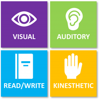
The VARK learning styles.
An essential part of being able to teach a beginner in any topic is being able to put yourself in their shoes and present the main learning points in a logical and digestible manner. We achieve this in a number of ways in our QGIS course, such as:
- providing visual learning aids such as demonstrations and an animated slideshow,
- providing examples that relate to the attendee’s careers and roles,
- combining self-paced, supervised exercises together with the trainer working through exercises on the projector screen (without ‘doing the work’ for people),
- asking attendees to answer questions after each learning module,
- varying the pace and teaching style throughout the day to cater for mental fatigue, and
- maintaining engagement and focus through (poor) humour and the occasional (terrible) analogy. Humour is an effective teaching tool for engaging participants and redirecting focus.
As a trainer, the most satisfying part of my job is seeing people have “Aha! moments” – those moments where they suddenly understand the fundamentals of a topic they have previously been baffled by. Anecdotally, I’ve mostly encountered Aha! moments when drawing diagrams or using analogies.
In Darwin, we inadvertently created a wave of Aha! moments on the topic of Coordinate Reference Systems (CRS). Our training data focuses on an area in southern WA, but for the Darwin training Chris put together an exercise looking at a national park in the NT. This simple switch in geolocation forced attendees to apply what they’d learnt about CRS, and switch from a WA-centric CRS to one that worked for the NT. Several people commented that they finally understood CRS. This is a great example of how talking about a topic won’t necessarily get the point across to someone, yet a simple additional step – making them apply that concept to a practical exercise – helps the penny drop.
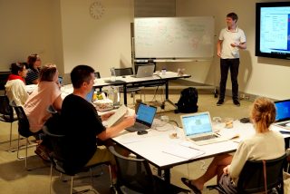
Chris answers the tough questions during one of our one-day courses in Darwin.
Every time we run the QGIS training we take away valuable observations and user feedback, and we are continually improving the course content and how it is delivered. We’re looking to bring our Beginner’s course to regional parts of WA and other States in Australia, and we’re currently working on new material for a potential Intermediate course (so stay tuned)!
If you’d like to attend our QGIS Beginner’s Course, or even discuss a more tailored training program for you or your staff, please drop us a line at training@gaiaresources.com.au, or connect with us on Twitter, LinkedIn or Facebook.
Tracey
Comments are closed.