Mapping applications that work on your mobile device – supporting your organisation’s workflows. That seems to be a common pursuit for many organisations out there that collect information in the field. Let’s get away from clipboards and paper records, connecting photos to dots on a map, trying to remember what it was we observed and to add it to our knowledge base back on the company network. In the era of smart phones and tablets, it seems like an achievable goal too. You have your choice of low cost Android, Microsoft and iOS devices, or tough tablets from the likes of Panasonic. There are a plethora of mapping apps out there – some free or cheap, and others that cost a fair bit of money over time (even the “free” ones). So how do you chose the best one for you?
Natural Resource Management (NRM) staff conduct a number of activities that involve checking things while in the field – on the farmers’ paddock or at community workshops. They collect mapping data and associated tabular information that is input, and for the ones that are involved in our project, they store and manage this spatial data online through GRID.
As part of the State NRM funded Capability grant we are working on to look at enhancements to GRID, we conducted a review of 45 mobile GIS apps out there on the market to see what would be suitable to act as GRID’s mobile component. It involved a general market scan looking at eight high level criteria including configurability, cost, app maturity, support framework and user friendliness. From these we found six apps (an even spread between Android and iOS) that deserved a more in depth look, and then we ran these six through their paces.
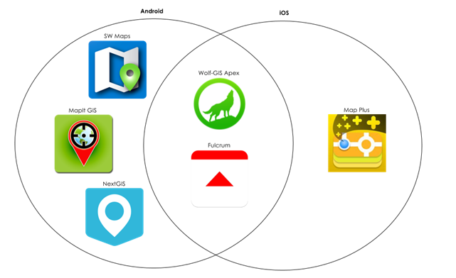
The top six mobile applications for integration with GRID that we found
Although we also focused on the ease with which they could integrate with GRID, the in-depth review tested the apps in real-world workflows, and from different perspectives (e.g. the GIS Analyst vs. Environmental Scientist). We looked favourably on apps that provided intuitive ways of generating area boundaries and lines on a mapping interface (e.g. not just points); but also noted there were some really promising apps that only catered for point data entry. Knowing that the true cost of incorporating a new technology into your business goes well beyond the licensing cost, we also had a crack at assessing the Total Cost of Ownership to the NRM community. This involved looking at how much time will this solution take to configure, to support, and what the costs are to license it over a 3 year period.
In the end, there we three real gems amongst those original 45: NextGIS, MapPlus and MapIT GIS – these ranked highly in a range of the areas we were investigating as part of this project, as shown below.
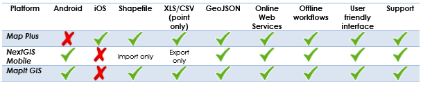
The three higher ranked mobile platforms for integration with GRID
This project was a pilot – it was to take a very wide open marketplace, full of churn and change, and identify the likely candidates through a simple pilot approach. So we came up with three recommendations;
- Recommendation 1: Conduct an internal trial of the chosen solutions, with consideration for the uptake of a common mobile GIS platform across the GRID community,
- Recommendation 2: The NRM community holds a workshop to discuss the path forward for adoption of one (or more) of these solutions that would meet future business needs, and
- Recommendation 3: Develop functionality in GRID to streamline the chosen GRID-mobile workflow.
Some of the NRMs that we work with on GRID are already looking at mobile solutions; and we’ve actually just put in to run a workshop at the coming State NRM and Coastal Conference to run just the workshop we need for this approach. So we’re looking forward to seeing the results of further testing (which we’ll also be looking at ourselves in our own internal GRID instance).
If you want to know more about our evaluation or process, then feel free to contact me in the office on (08) 92277309 or via email. Alternatively, you can start a conversation with us via Facebook, Twitter or LinkedIn.
Chris
Comments are closed.