Piers’ note: Chris and I have been discussing this for a while, and this is the first of a likely few blogs about data in the Environmental Regulation field. Of course, with the upcoming WA government department changes, some of the names here might end up changing!
For decades, Western Australia has had environmental regulations governing the approval and monitoring of development applications. In particular, Part IV of the Environmental Protection Act sets out the Environmental Impact Assessment (EIA) process, while Part V and Schedule 5 of that same Act provide Clearing Regulations and principles controlling the removal of native vegetation for the purposes of development. There’s also a lot of discussion at the moment on the new Biodiversity Conservation Act (which Piers will blog about in due course).
As a result of the EIA legislation, every mining company hoping to convert a hot prospect to a gold mine, every utility wanting to pipe gas or water to their customer base, and every land developer wanting to transform land into homes has worked through a process to limit the impact to our State’s environment. Beyond the initial EIA approval, organisations are also obliged to report annually on activities to prove they are only disturbing ground to the degree and extent approved in their application. It doesn’t stop there either – the approval process for resource companies ties into new Biodiversity Conservation legislation, the Mine Rehabilitation Fund (MRF) and the National Pollutant Inventory (NPI) Reporting. Gaia Resources even started talking about how these types of data could be linked back in 2010!
As a spatial scientist, it strikes me that these processes have generated (and continue to generate) a lot of data coming from proponents… which is very valuable data for the State. Beyond that exchange of information on a project by project basis, what happens to it? And how is it used in the long-term or across space to increase our knowledge of our State’s environment? Do we aggregate it and look at cumulative impacts across all projects in a bioregion, for instance (like we did with native vegetation clearing permits back in this blog, one of the interactive maps from which is included again below).
One of the Cumulative Impacts interactive maps we produced back in August, 2016
The question I’ve recently been asking myself is, do the Regulators have the tools they need to monitor actual ground disturbance effectively – such as a system that alerts them if the actual clearing in an area exceeds a threshold for that vegetation community? Most importantly, is the data submitted in a way that can support these types of adaptive strategies?
I believe one of the big challenges to doing this has always been about data consistency and quality. What I have heard from industry colleagues (and this is supported by the combined experience from the Gaia Resources team) is that data arrives from proponents in a number of formats and to varying degrees of data quality (even including hand-drawn maps). Throughout my own professional history (on both sides of the fence) I noticed that everyone has a slightly different take on how to manage and submit their environmental data. The absence of data standards or controls at the front end, makes the submitted information prone to errors of interpretation and inconsistency across projects. Inconsistency like this makes data difficult or impossible to aggregate, and as a result each project can only be considered in isolation. It’s great to see that regulators – like the Department of Mines and Petroleum (DMP) – are getting savvy about using spatial technologies to streamline the approval and monitoring process.
As an example, DMP have just released the Program of Work (POW) Spatial map-based application allowing proponents to enter their proposed exploration and mining activities. A couple of weeks ago I went along to get trained in this system so that we can assist our clients in preparing their data for submission. Through the POW Spatial tool, proponents can either load their existing shape files or create spatial boundaries on screen (i.e. drawing proposed activities). The system then conducts automatic checks by intersecting the proposed activities with other data layers of environmental and cultural significance, alerting the proponent of the results. Any areas which need follow-up or clarification can then be addressed before the application is submitted. The idea is that this should reduce assessment times, but a key side benefit is that it should increase data quality and consistency.
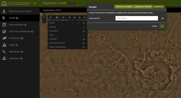
A screenshot from the new DMP POW Spatial tool
For years Gaia Resources have worked with mining companies on capturing ground disturbance mapping; which is the one of the datasets that is required for the POW Spatial tool. Our previous projects (such as in creating a range of different outputs for our clients, including maps, datasets and statistics) mean that we can readily create and supplying the data you would need for the regulators.
So, if you are looking for assistance either in gathering the data or for lodging it in the POW tool, feel free to contact me directly via chris.roach@gaiaresources.com.au. Alternatively, you can interact with us via our social media accounts – such as Facebook, Twitter or LinkedIn.
Chris
Comments are closed.