Within my first two weeks of moving to Darwin, Rohan Fisher from the Darwin Centre for Bushfire Research invited me to the Savanna Fire Forum (see our 2019 and 2020 blog of that event) in what turned out to be an awesome introduction to some of the most topical environmental challenges facing the northern half of Australia. Speaking to people there, I immediately knew Gaia Resources had a role to play, and today I’m very proud to announce the release of the NAFI (Northern Australia and Rangelands Fire Information) plugin for QGIS.
A video introduction to the new NAFI fire mapping QGIS plug-in.

The new NAFI fire mapping QGIS plug-in with side panel for quick search and upload of fire scar and hotspot layers.
QGIS is a free and open-source software product for mapping and analysis, and this new plug-in is one part of a bigger project we are currently delivering between Tom Lynch and myself in Darwin, and our team in Perth. Funded by the Commonwealth government and Charles Darwin University, the project aims to broaden the uptake of fire mapping data to indigenous rangers, conservation and environmental scientists and carbon industry managers. As Rohan describes in his article in The Conversation (link), the tropical savannas of northern Australia are among the most fire-prone regions in the world, and fire management systems in use – led in large part by Indigenous land managers – is world-leading.
“The NAFI Plugin will provide an important additional resource to support fire managers across northern Australia and the Rangelands. The service provides critical near real-time information on active fire as well as regular updates [to] burnt area mapping. This supports strategic fire management planning and response for thousands of fire managers across Australia. The addition of the NAFI plugin will provide an opportunity for more sophisticated planning with NAFI data and a portal for building GIS capacity amongst land managers already using NAFI. NAFI is already the most used Land and fire information portal for across most of Australia. The Plugin will provide additional access and promotion of this important service.”
— Rohan Fisher

Relatively safe ‘cool’ burns can create firebreaks. (source: DCBR)
Basically, this plugin is free and available in the QGIS software platform (also free!). People now have greater accessibility to the web mapping services that are already available on the NAFI website, with Open Geospatial Consortium (OGC) web map services, common base maps and data downloads now just a click away.
The fire activity mapping is based on information from satellites, such as hotspots (locations of recently burning fires) and fire scars (maps of recently burnt country). Hotspots are sourced from Landgate Western Australia (from NOAA and NASA satellites) and Geoscience Australia (from NASA satellites). Fire scars are sourced via NAFI and produced by the Darwin Center for Bushfires Research (Charles Darwin University). The coverage of the NAFI data products actually includes a large proportion of Australia including the vast desert and Rangelands regions.
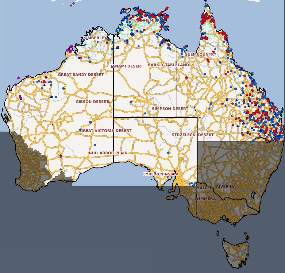
Coverage of NAFI fire mapping covers 70% of Australia (source: NAFI website)
We are really excited about this new addition to the NAFI infrastructure, and are looking forward to hearing the feedback from bushfire and carbon industry experts on how it will benefit their planning and operations.
If you want to know more about this topic, or you want to talk about your own adventures in fire management and GIS software, please feel free to start a conversation on Twitter, LinkedIn or Facebook, or e-mail me directly on chris.roach@gaiaresources.com.au
Chris
Comments are closed.